ABOUT THE PROGRAM
SAPWAT 4 is essentially an enhanced and improved version of SAPWAT 3, the program that is extensively applied in South Africa and was developed to establish a decision-making procedure for the estimation of crop irrigation requirements by irrigation engineers, planners and agriculturalists. After the development of the original SAPWAT program, the FAO published the “Irrigation and Drainage Paper No. 56; Crop evapotranspiration. Guidelines for computing crop water requirements.” This intuitive and comprehensive document is highly acclaimed and has become accepted internationally. As the calculation of crop evapotranspiration is the first and essential element of any routine for estimating crop irrigation requirement, the decision was taken to reprogram the original SAPWAT and SAPWAT 3, and now SAPWAT 4, has at its core the computer procedures contained in FAO 56.
WEATHER STATIONS
The irrigation requirement of crops is dominated by weather, particularly in the yearly and seasonal variation in the evaporative demand of the atmosphere as well as precipitation. SAPWAT 4 has included in its installed database comprehensive weather data that is immediately available to the user:

- Firstly, it includes the complete FAO CLIMWAT weather data base encompassing not only South Africa, but many other countries in the world where there is irrigation development. CLIMWAT comprises 3262 weather stations from 144 countries, including South Africa, and contains long-term monthly average data for calculating Penman-Monteith ET0 values as well as rainfall. While CLIMWAT weather data output is monthly averages, SAPWAT 4 calculations are based on daily values requiring interpolation. This has been facilitated in SAPWAT 4 by statistically fitting a curve to the monthly ET0
- The second installed set of weather data in SAPWAT 4 consists of derived weather stations and is only applicable to South Africa. This data set was developed from the South African Atlas of Climatology and Agrohydrology by the team from the School of Bioresources Engineering and Environmental Hydrology, University of KwaZulu-Natal. The derived weather stations are located at the centroids of the polygons that represent each quaternary drainage region of the country and provide not only comprehensive coverage, but also 50 years of historical (1950- 1999) daily weather data. This capability has major implications when it comes to planning and strategy development. It is possible to select any day during this period and access the maximum and minimum temperatures, humidity, rainfall, solar radiation and ET0.
SAPWAT 4 provides facilities for importing additional weather stations or weather data generated by the FAO New LocClim program. If the weather station database consists of average monthly values, like CLIMWAT, then manual importation is recommended, but if the data is more detailed there are facilities for formatting and importing the data files as a package.
CROP DATA
FAO four-stage crop coefficient curve
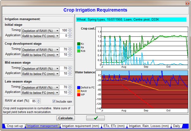
SAPWAT 4 utilises the four-stage crop development curve procedure based on relating crop evapotranspiration in each stage to the short grass (Penman-Monteith) reference evapotranspiration by applying a crop coefficient. Typical values of expected average crop coefficients under a mild, standard climatic condition are published in FAO 56 and applied in SAPWAT 4. FAO 56 makes provision for this and provides for making the necessary corrections. SAPWAT 4 applies these corrections, but FAO 56 makes no provision for the effect of climate, planting date, management strategies or crop varieties on the individual crop development stage lengths or the total irrigation period. SAPWAT4 provides for this with default stage length values for each of the crops listed for each of the five climatic zones and in addition has options for each crop where there are differing cultivars and modifies the stage lengths where these are influenced by planting dates. This is like the approach that was adopted with the original SAPWAT, but editing has been greatly simplified and this makes it much simpler for a user to simulate local conditions or even to add new crops.

The crop data editor
The crop coefficient files were developed per rules derived with the help of crop scientists. Experience showed that it was necessary to modify the approach to suit irrigation as opposed to the normal rain-fed development stages. Editing has been simplified by the provision of options available on drop-down menus. It is envisaged that users concerned with groups of irrigators would develop their own sets of defaults tailored to their conditions.
CLIMATE
SAPWAT4 incorporates the internationally recognised Köppen-Geiger climatic system. The system is based on temperature-rainfall combinations so that the climate of the weather station can be classified by using the temperature and rainfall data of a weather station record. One adaptation was made, that is the second letter of the three-letter code that indicates rainfall seasonality, is not used because rainfall seasonality is superseded by irrigation scheduling. In the case of South Africa, this resulted in the number of climatic regions being reduced to five and it is no longer necessary for the user to have to decide in which climatic zone a weather station falls because this is determined by the program.
CROP IRRIGATION
Water Balances
SAPWAT4 makes use of the FAO 56 procedure that separates soil evaporation from plant transpiration and, therefore, conforms to the FAO 56 defaults that determine soil water characteristics and evaporation parameters. Fortunately, FAO 56 specifies soils according to the familiar sand, silt and clay criterion into nine classes. The profile water balance during irrigation is also calculated and tabulated strictly in accordance with FAO 56 methodology.
Irrigation Requirement
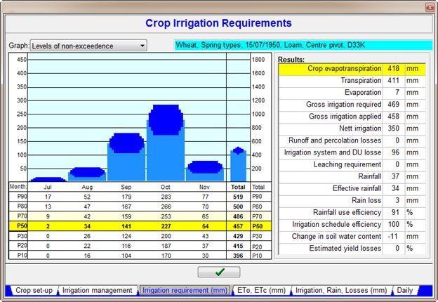
The methodology for estimating crop evapotranspiration under standard conditions has been well researched and due allowance can be made for nonstandard conditions arising from unusual circumstances and the realities of practical management. In short, we can be reasonably confident that we can estimate the amount of water being used by the crop and thus the net irrigation requirement. Unfortunately, we cannot have the same confidence in estimating the gross irrigation requirement, how much water must be made available to match the evapotranspiration plus the losses that occur.
System efficiency
Water that evaporates in the air or is blown away from sprinkler systems is regarded as a loss, so is water that is applied to uncultivated areas of the field. In SAPWAT4 this is reflected by System Efficiency (%). If too much water is applied and penetrates below the roots, this is also regarded as a loss; it is normally the result of an uneven distribution of water by the system or by lack of uniformity in the soil itself. In SAPWAT4 this is referred to as Standard DU (%). It is very difficult to provide standardised or even defensible defaults for these values. The approach that SAPWAT4 has followed is to provide a preliminary default value for System Efficiency and to set Standard DU at 100%. If, through measurement or judgement, the user can, however, come up with real-life values, he can substitute these manually.
Application range
SAPWAT4 can be applied for estimating the irrigation requirements for a single crop, for a field with multiple cropping, for a single farm, for a group of farms (Water User Association (WUA)), for a group of WUAs, for a (Water Management Area (WMA)) or for river basin and basin sub-units. Output is provided, where appropriate, in millimetres and cubic metres. Provision is made for printing comprehensive output tables and/or saving to file and/or exporting for further processing by spreadsheet applications.
ENTERPRISE BUDGETS
The inclusion of an economic analysis module in SAPWAT4 to enhance its capability as a planning tool has been expressed by more than one user over the last few years as the conviction grew that planning irrigation water use without considering the economic impact does not give enough of a picture on which to base future planning for crop production. SAPWAT4 makes provision for the introduction of enterprise budgets as part of the irrigation water requirement planning process. Income, expenditure and gross profit margin are reflected in the crop irrigation requirement tables. There is a linkage between the economic factors and the crop irrigation requirements so that if there is a variation in crop irrigation requirements with altering strategies, the impact on costs will be reflected and should there be a depression in yield, the impact on income and gross profit margin will also be reflected.
RAIN WATER HARVESTING
SAPWAT4 provides a rainwater harvesting module aimed at small areas, typically small farms or household gardens, therefore the water harvesting module is only available if the cultivated and irrigated area is less than 1 ha. The 50-year daily weather records provided by the derived weather stations are particularly useful because a thorough understanding of the rainfall pattern is essential when assessing the viability and developing suitable systems for rainwater harvesting. A water balance is the background to this module. Total of water requirement is the sum of the irrigation and household requirements, while water gain on the irrigated area is the sum of the rain that falls directly on the garden beds and run-off from the roof and surrounding areas that can be augmented by borehole water and grey water from kitchen and bathroom waste. Run-off can be harvested from any combinations of the roof, hard-packed soil around the homestead or adjoining roadways or from an adjoining area of natural vegetation. The storage to provide water for the dry season can be any combination of totally covered, impervious containers, open impervious containers or open ponds. The module can also be used to estimate the harvest width area of the infield rainwater harvesting techniques where runoff from an area of slow infiltration soil is stored in a shallow basin where the water can concentrate and infiltrate into the soil adjacent to the plant row.
Disclaimer:
The SAPWAT 4 program and documentation contained in this website emanate from research projects financed by the Water Research Commission (WRC) and are approved for release. Although every precaution has been taken to ensure that the information is correct, application of results is at the risk of the user.
SAPWAT 4 Copyright © 2016 Water Research Commission